
Top 10 highest mountains in Vietnam
The Northwest region of Vietnam, especially the majestic Hoang Lien Son mountain range spanning Lao Cai, Lai Chau, and Yen Bai provinces, boasts the country's tallest and most breathtaking peaks. Known as the "Roof of Indochina," this area is a true haven for trekking lovers, offering ancient virgin forests, spectacular seasonal rhododendron blooms, ethereal seas of clouds, and historic border markers along the Vietnam-China frontier. Conquering these summits requires physical stamina, preparation, and often experienced guidance, but the rewards are profound: intimate encounters with untouched wilderness and vibrant cultures of ethnic groups like the H'Mong, Thai, and Dao.
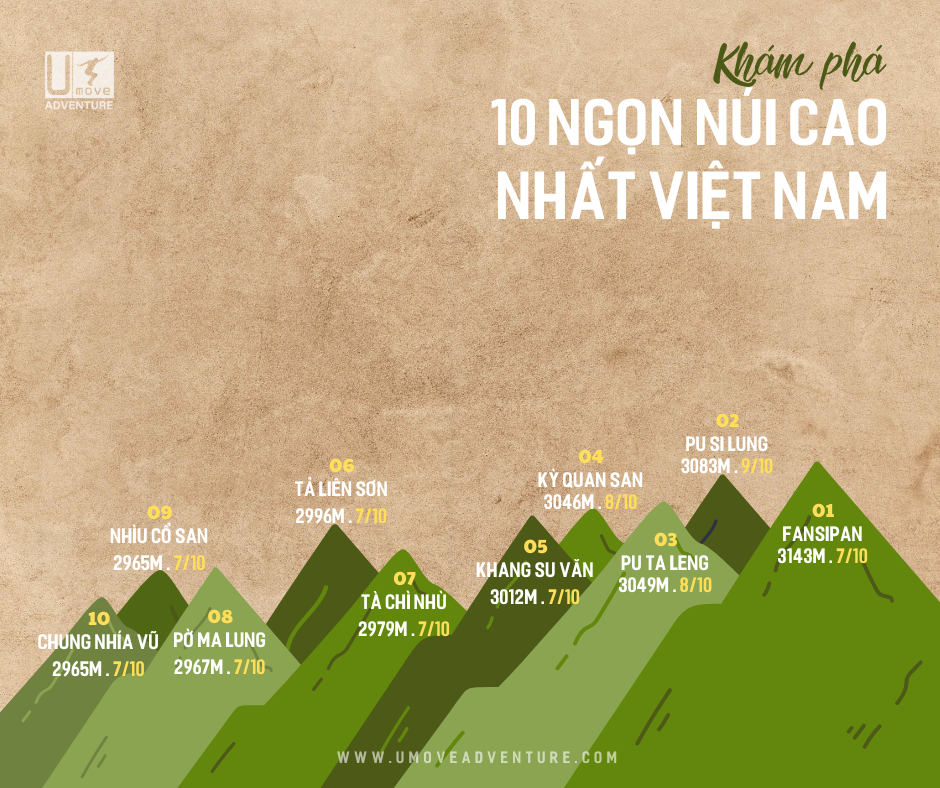
1. Fansipan (3,143 m) – The "Roof of Indochina" Situated in Hoang Lien National Park, just 10 km from the charming town of Sa Pa in Lao Cai province, Fansipan stands as Vietnam's undisputed highest peak. While a modern cable car provides easy access for casual visitors, serious trekkers prefer the classic route starting from Tram Ton Pass. This 2-day, 1-night adventure features varied terrain — from dense bamboo groves and moss-draped forests to demanding steep inclines. Overnight stops are typically at 2,200 m (midday) and 2,800 m (evening). The optimal season runs from September to April, when trails are dry and temperatures are manageable. At the summit, panoramic vistas unfold over misty Sa Pa valley and the endless ridges of Hoang Lien Son.
2. Pu Si Lung (3,083 m) – Vietnam's Second-Highest Peak Perched in Pa Ve Su commune, Muong Te district, Lai Chau province, directly on the Vietnam-China border, Pu Si Lung is a formidable challenge reserved for seasoned adventurers. The expedition spans 3 days and 2 nights, traversing more than 60 km of rugged paths. Trekkers ford around 11 streams, navigate pristine jungles, bamboo thickets, oak woodlands, and groves of ancient rhododendrons hundreds of years old. A memorable highlight is reaching border marker 42 at 2,866 m — the second-highest marker in Vietnam. The remote, barely touched landscape here delivers an authentic sense of discovery.
3. Putaleng (3,049 m) Found in Ta Leng commune, Tam Duong district, Lai Chau, Putaleng is infamous for its relentlessly steep and unforgiving terrain. Most groups depart from Ban Pho village in Ho Thau commune, following the Ta Leng trail over 2 days and 1 night. The route crosses the serene Thau Stream, dotted with crystal-clear natural pools among boulders, but the true test comes from three almost-vertical sections with no level ground — often requiring hand-over-hand climbing using tree roots and branches. Fortunately, thick forest canopy shades most of the path, keeping conditions cool even under the tropical sun.
4. Ky Quan San (3,046 m) – Also Known as Bach Moc Luong Tu Straddling the natural boundary between Lai Chau and Lao Cai provinces, this peak only opened to organized trekking in 2012. The favored starting point is Sang Ma Sao commune in Bat Xat district, Lao Cai. The sub-peak known as Muoi Salt Mountain exceeds 3,000 m and offers some of the most spectacular cloud-sea and sunrise viewpoints in northern Vietnam. Visiting in May coincides with the H'Mong rice-planting season, when terraced fields shimmer with water and fresh green shoots.
5. Khang Su Van (3,012 m) – Also Called Phan Lien San or U Thai San Located in Dao San commune, Phong Tho district, Lai Chau, this approximately 20 km trek has drawn enthusiasts since its first documented ascent in 2015. A standout feature is passing border marker 79 — the highest elevation border marker along the entire Vietnamese frontier.
6. Ta Lien Son (2,996 m) – Known as Co Trau (Buffalo Horn) The tallest summit in the Ta Leng area of Tam Duong district, Lai Chau. This moderate 2-day, 1-night trek winds through pristine forest filled with moss-covered ancient trees. A convenient rest station at 2,400 m aids recovery. Prime visiting windows are April–May, when rhododendrons explode in vivid reds, or September–October for stunning autumn foliage transitions.
7. Ta Chi Nhu (2,979 m) Dubbed the "roof" of Yen Bai province within the Pu Luong range, in Xa Ho commune, Tram Tau district. Trekking routes were pioneered in 2013. Late autumn blankets the slopes in striking red and purple rhododendron blossoms.
8. Po Ma Lung (2,967 m) Situated in Ban Lang commune, Phong Tho district, Lai Chau, this peak surged in popularity from 2017 onward. Although ranked eighth in height, the vertical gain is dramatic — nearly 2,200 m from a trailhead at around 800 m. The full journey covers over 40 km of dense forest over 3 days and 2 nights.
9. Nhiu Co San (2,965 m) – "Buffalo Horn" in H'Mong Language In Sang Ma Sao commune, Bat Xat district, Lao Cai, the range's twin pointed summits resemble buffalo horns rising skyward. March to April sees slopes awash in red and purple rhododendrons, while late December to early January occasionally brings light snow to the top. Part of the historic trail incorporates the Pavi stone path constructed during French colonial times in the early 20th century.
10. Chung Nhia Vu (2,918 m) Nestled in Nam Xe commune, Phong Tho district, Lai Chau, close to border markers 83–85. The deeply mossed, nearly virgin forests lie far from settlements, forming a natural frontier barrier with China and attracting dedicated explorers. The rhododendron flowering season from March to May transforms the entire Northwest into a living canvas of crimson, purple, and pink — arguably the region's most photogenic period. These epic treks push physical and mental boundaries while rewarding participants with profound immersion in Vietnam's wild highlands, glimpses into indigenous ways of life, and ever-changing seasonal splendor.
Umove Adventure is a premier tour operator specializing in expertly guided trekking expeditions to Vietnam's tallest and most stunning mountains. With seasoned local guides, comprehensive logistics, and a strong emphasis on safety, they help adventurers of all levels achieve these extraordinary summits responsibly and memorably.